Niubalus Logistics — Longwe i kamap
Video © Skyways Air Transportation · Skyways V3

Home / PNG Sky Highway

Our plan

The PNG Sky Highway

A national drone logistics network for Papua New Guinea: where roads end, the Sky Highway begins.

Three tiers

The right aircraft for every leg.

No single aircraft does everything. The network matches each leg of the journey to the most efficient way of flying it — from international port to village health post, without roads or helicopters.

Tier 1 · Between hubs

Trunk freight & heavy lift

Bulk cargo between Port Moresby and the regional bases by airline and sea freight, with a heavy-lift helicopter drone (coming soon) carrying up to 250 kg.

Tier 2 · Middle mile

Long-range cargo drones

Autonomous cargo aircraft in the 40 kg class — such as the Skyways V3, coming soon — flying hundreds of kilometres from a base to district towns, airstrips and mine sites.

Tier 3 · Last mile

Precision delivery

The Wingcopter 198 carries blood, vaccines, anti-venom and medicines the final stretch to a health post or village drone pad.

How it grows

One base at a time.

Each phase runs as a working logistics operation on its own — earning revenue, proving the model and training the crews for the next one. Timing depends on funding and partners.

  1. Prove it

    Western Province: the Kiunga – Tabubil corridor, anchored by our contract with Ok Tedi Mining. Medical and mining cargo in PNG's toughest flying conditions.

  2. Hub & train

    Port Moresby: the national control room for every flight, heavy maintenance and the pilot school — the Niubalus Academy.

  3. Highlands

    Goroka base serving the Highlands, Madang and East Sepik. Mount Hagen and Lae are being studied as further bases for the densely populated Highlands and Momase region.

  4. Islands & Milne Bay

    Rabaul/Kokopo for New Britain, New Ireland and Bougainville; Alotau for the Milne Bay island groups — mostly over-water routes.

  5. Every province

    A ring of village drone pads around every base, linking health centres, schools, district towns and mine sites across all four regions.

The bases

Planned hubs.

Indicative locations; final sites are chosen with provincial governments and landowners.

First service area

Kiunga – Tabubil

Western Province: Fly River corridor, mine-site and border communities, Daru and the South Fly.

Super hub

Port Moresby

Control room, pilot school, maintenance and spares; national medical stores; Central, Gulf and Oro provinces.

Regional hub

Goroka

Eastern Highlands and the Highlands provinces, Madang and East Sepik — high-altitude operations.

Regional hub

Rabaul / Kokopo

East and West New Britain, New Ireland and Bougainville.

Regional hub

Alotau

Milne Bay mainland and the Trobriand, Woodlark and Louisiade island groups.

Under study

Mount Hagen & Lae

A second Highlands base and a north-coast freight gateway, subject to site surveys.

The fleet

In service and coming soon.

Today our pilots are type-rated on the Wingcopter 198 for last-mile medical delivery. Two larger aircraft are being prepared for the middle mile and heavy lift.

In service · Wingcopter 198Coming soon · long-range VTOL
Video © Wingcopter · © Skyways Air Transportation
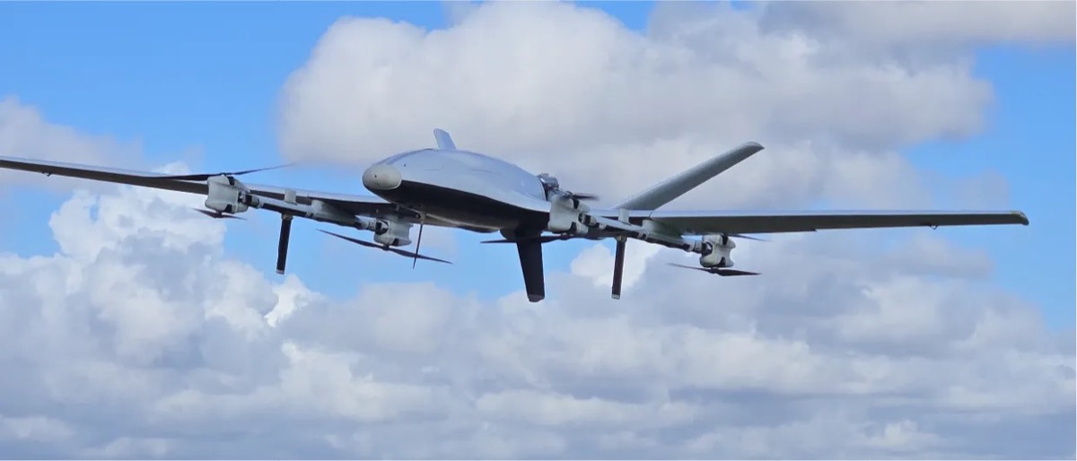
Skyways V3 long-range cargo drone in flightComing soon
Image © Skyways Air Transportation

Skyways V3 — long-range cargo drone

A fully autonomous long-range cargo aircraft from Skyways (USA): up to 100 lb (about 45 kg) of cargo, more than 1,000 miles (about 1,600 km) of range and around 20 hours in the air. It would carry middle-mile freight from our bases to district towns, airstrips and mine sites.

~45 kg useful load1,600+ km range~20 h endurance0.2 m³ cargo

Manufacturer figures; aircraft in development (expected 2026).
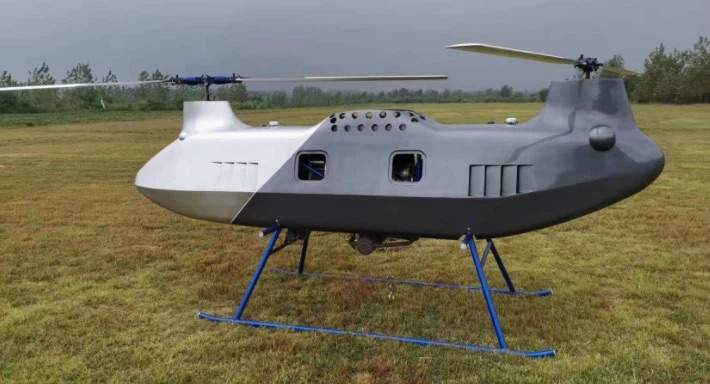
Tandem-rotor heavy-lift helicopter droneComing soon

Tandem helicopter drone — heavy lift

An unmanned tandem-rotor helicopter carrying up to 250 kg over 400 km — the heavy-lift connector between our bases, and a disaster-response aircraft that can hover and lower cargo where nothing can land.

250 kg payload400 km rangeTandem rotorsHover & sling-load

Planned specification for the model under evaluation.

At every drone pad

More than a landing pad.

Each base needs satellite links for flight control. Extending that link to the village pad gives communities reliable internet for the first time — for telehealth, school, mobile banking and ordering what they need.

  • Solar power and battery storage
  • Satellite internet and community Wi-Fi kiosk
  • Online booking and digital payments — no cash handling
  • Local receiving staff trained by Niubalus
Built safely

Run under PNG's aviation rules.

Operations are designed to Civil Aviation Rules Part 102. Our operator certificate (UAOC) exposition has been submitted to CASA PNG, and every flight is tracked from the control room, with ADS-B awareness of crewed aircraft.

  • Dual satellite and mobile data links for flight control
  • Type-rated pilots and an in-house training programme
  • Community consent and landowner agreements for every site

Partner with us on the Sky Highway

Provincial governments, health partners, mines, manufacturers and investors: talk to us about a route, a base or the whole network. Our whitepaper is available to qualified investors under NDA.